HILLFORT on Creigiau Gwineu (Fig. II2), a long
spine of outcrop running N.E.-S.W., and rising to a height of
nearly 800 ft. above O.D., overlooking the sea to the S. ofthe
village of Rhiw. The outcrop forms an escarpment with a
sheer cliff 30-40 ft. high along its N.W. side, and a gentler
slope on the S.E., seaward side. The defences of the fort make
skilful use of the natural features and incorporate the highest
point of the ridge at their S.W. end. The fort is an elongated
oval in plan, its main axis following that of the ridge, and is
rounded at the N.E. but pointed at the S.W. end. It measures
400 ft. in length and 188 ft. in maximum breadth. At the
S.W. end and along most of the N.W. side the natural precipices
serve as the only defence, though about half-way
along the N.W. side the head of a narrow gully is walled off.
Elsewhere the defences consist of a single massive wall from
6 ft. to II ft. in width, following the 750 ft. contour round the
N.E. end, falling to 740 ft. at the lowest point on the E., then
rising steadily along to the S.E. side towards the highest point
of the ridge. The rampart is faced in some places with orthastats
and in others with roughly coursed dry walling, with a
core of loose stones; large natural boulders or small outcrops
of rock are incorporated in the line of the faces wherever
possible. The whole length of walling is extremely ruined
and seldom stands more than one course high for any distance.
On the E. and again about half-way along the S.E. are narrow
gaps, 3 ft. 6 ins. and 6 ft. 6 ins. in width respectively, but
neither is certainly original and the main entrance into the
fort is formed by a large natural gully on the W., 22 ft. in
minimum width, in which rock falls and the construction of a
modern wall have completely masked any details ofthe original
gateway.
The fort is divided into two ‘wards’ by a wall, similar in
character and dimensions to the main rampart, running northwards
from a point a little to the W. of the S.E. gap, over the
rocky spine in the centre of the fort, to terminate on a bold
crag on the N. side of the site.
Three circular huts are visible in the western ‘ward’:
(i) 20 ft. in diameter, against the inner face of the rampart just
to the W. of its junction with the cross-wall; (ii) 18 ft. in
diameter, a little to the W. of this; and (iii) 16 ft. in diameter,
at the N.E. base of the tower of outcrop overlooking the S.
side of the main entrance.
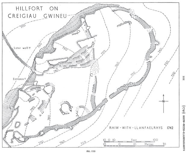
From the base of the north-western cliff, on the N. side of the entrance, a much ruined wall runs across the flat ground towards the N.W. for a distance of at least 125 ft. This is older than the present field walls but may be later than the hillfort.
Condition: fair. 17 vii 58 44 S.W. Unnoted
Rhannwch - Share and Enjoy
By providing a comment and or uploading a photograph(s) of this heritage site, you are contributing to the project and playing your part in the management of our fragile heritage and their future survival. Creative Commons Attribution-NonCommercial 4.0 International (CC BY-NC 4.0) will allow you to retain your attribution (as photograph author copyright), but will also allow the data to be shared - incorporated into the heritage management systems for future reference and not restrict future reuse.