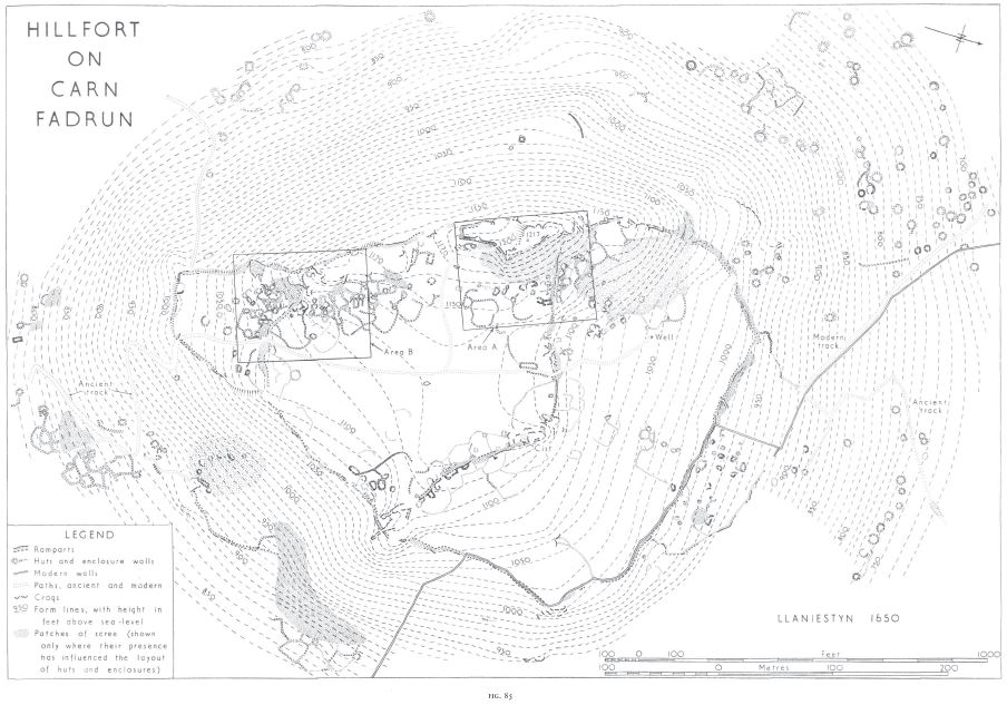
(1650) CARN FADRuN (Figs. 85-7, plates 4, 5, 6) is a hill of
igneous rock which forms the dominating feature of western
Lleyn. Its sides rise steeply for more than 200 ft., and are
broken by rocks and scree, but the ascent, though difficult, is
not generally impossible. A little above the 1,000 ft. contour
the slope becomes gentler, and the top of the hill has a large
area which is nearly level at about 1,120 ft. above D.D. Along
the W. side the ground rises again to form a rocky ridge with
its summit marked by a trigonometrical station at 1,217 ft.
above D.D.
The top ofthe hill is defended by the remains of two strong
stone walls, probably representing two periods of pre-Roman
fortification, a smaller fort of about 12 acres having been
succeeded by a larger of about 26 acres. These defences are
probably to be associated with the stone hut-circles which
occur on the hill. In addition to these round buildings there arc
numerous small huts ofirregular shape cut into the ruins ofthe
earlier rampart, and associated with irregular enclosures.
These resemble the huts at Tre’r Ceiri (Vol. 11, No. I056)
which have been assigned to the latter part of the Roman
period. Finally, the highest part ofthe W. ridge has been made
into a fortress by the construction of a stone wall. This can
almost certainly be identified as the ‘castle of the sons of
Dwain’ mentioned in II 88 as having been newly built. 1
Some ofthe rectangular foundations nearby shouldprobably be
associated with this castle.
In addition to the huts within the early defences, numerous
round and irregular foundations, some with enclosures, occur
on the slopes of the hill.
In the absence ofexcavation2 this analysis ofthe remains rests
on their surface appearance, and may conveniently be used
as a basis for the detailed description. Sites are identified where
necessary by their approximate true bearing and distance in
feet from the trigonometrical station on the summit (the
bearing of the long sides of the general plan (Fig. 85) is 345°).
The earliest structure is a robbed and ruined cist (at 77°,
580 ft.). It appears to have measured about 8 ft. (at 30°) by
4 ft., the sides being formed of large slabs set on edge; the E.
half is ruined. A scatter of loose boulders suggests the former
presence of a cairn robbed to build the adjacent rampart.
This burial was presumably of the Bronze Age, its only
connection with the hiilfort being the accident of location.
In both early periods of occupation, the ramparts were of
the same character, formed by strong walls of unmortared
rubble with almost vertical faces of large blocks. These walls
now appear as banks of loose boulders with traces of facing
visible in places; a well-preserved stretch of outer face, of the
earlier period, is visible N. of the summit (at 20°, 100 ft.;
plate 6). The ramparts seem to have averaged about IO ft.
in thickness, but to have varied between 8 ft. and r5 ft. There
is no direct evidence for their relative date from junctions or
overlapping, but the inner wall can be regarded as the earlier
because it is more ruinous than the outer (Plate 6) and has
been much robbed, so that in places, particularly on the E. of
the hill, it is no longer traceable; the outer rampart, on the
other hand, taken in conjunction with natural features, still
forms a complete defensive circuit.
There appear to have been one N. and one S. gate in each
period. They are so ruined that no details oftheir construction
are visible. The N. gateway of the second period (at 240°,
730 ft.) has now a revetment lining each side of the passageway,
but this was built after the wall had fallen into ruin;
it may be modern, but is perhaps more likely to be associated
with the construction of the irregular huts. The gap in the E.
side ofthe earlier rampart (at 95°,730 ft.) is a later breach.
By analogy with other forts in Caernarvonshire (e.g. Garn
Boduan, No. r523) these defences should probably be associated
with round huts, which are frequent on the slopes of the
hill, although only nine or ten can be identified. within the
larger defended area. They range from IS ft. to 25 ft. in
diameter, with walls 3-4 ft. thick, generally faced with laid
masonry but sometimes with orthostats. Some may have been
obliterated by the irregular huts. One (at 135°, 770 ft.) seems
to have been robbed of all its large stones, and another (at 3°,
r60 ft.) has been subdivided by a cross-wall (cJ. Nos. 59 and 61
at Tre’r Ceiri, Vu!. 11, No. r056).
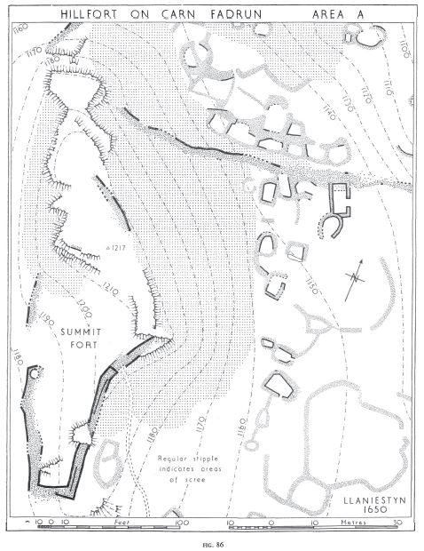
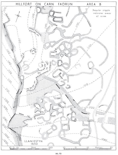
Apart from the defences, however, the most conspicuous
feature of the site is the mass of small huts, irregular or roughly
quadrilateral, which have been formed in the natural scree and
in the ruins of the earlier rampart (Plate 4).3 Associated with
these are irregular enclosures formed by low banks of piled
stones (Plate 6). The character of these remains can best be
judged from the two plans showing limited areas to a larger
scale (Figs. 86, 87). The huts resemble those on Tre’r Ceiri
which are probably of the latter half of the Roman period
(Vol. H, p. 102b), and the enclosures are similar to the extramural
enclosures there, but on that si.te the huts lie within
the fort and the enclosures are outside the main rampart. The
long building close to the footpath (at 75°, 360 ft.) seems later
than an enclosure wall, and two other structures (at 58°,190 ft.
and 155°, 280 ft.) are probably, from their regular plan, later
than the mass of irregular huts. On surface evidence, it is
impossible to say whether these three are to be associated with
the 12th-century castle on the summit or whether they represent
the remains of later hafodau.
The latest defences on the hill are those which strengthen the
crag forming the summit (Fig. 86). Although no mortar has
been used, and they show little similarity to any known
medieval work, there can be little doubt that these represent
the ‘castle of the sons of Owain’ mentioned by Giraldus
Cambrensis.4 The form of the ground gives a rough resemblance
to a motte and bailey, but it seems unlikely that the
position was selected on this account.
Access to the summit is difficult except on the N.E., where
the lowest courses of a wall remain in places. A short stretch
of facing stones one course high also survives on the S. Apart
from these, any structure which may have occupied the summit
has left no surface traces. On the lower ground to the S.,
however, the remains are better preserved. Near the N. end
of the E. wall (at 150°, 80 ft.) was the entrance, a simple gap
about 6 ft. wide. It seems to have been deliberately blocked in
antiquity, and only the S. revetment of the entrance passage
is visible. To the S. the wall is well-preserved, about 8 ft.
wide and standing about 3 ft. high externally; the parapetwalk
survives for most of its length. The masonry is smaller
than that of the early ramparts and spalls have been used in
places between the larger stones. The remainder of the circuit
is morc ruinous, and part of the W. side has collapsed and is
no longer distinguishable from the scree upon which it was
built. It is not clear whether the circular hollow near the middle
ofthat side (at 1910
, IIoft.) is original or whether it is a recent
disturbance; the latter seems more probable.
The only other feature within the defences is the Well
(at 23°, 415 ft.), a pit about 2 ft. square by 18 ins. deep, lined
with slabs. There is no evidence as to its date.
Other structural remains to be associated with the hillfort
occur on the slopes ofthe hill. Terraced trackways ascend the
hill in zig-zags to the N. and S. gateways in the outer rampart.
The terracing does not continue beyond these points, and they
are therefore probably of the second period of construction.
That on the S. is particularly well built and graded. Round
huts exist on all sides except the E., but the greatest concentration
is on the N. and N.W. The huts here are constructed like
those within the defences, but form levelled platforms in the
steep hillside, and range from 10 ft. to 25ft. in diameter. They
are generally very well preserved. Groups of small irregular
huts also occur, mainly on the N. and S.E. Those on the N. are
enclosed by an irregular rampart forming a loop with its
ends on the main outer wall. On the S.E. also there is a length
of similar but slighter rampart terminating on masses of scree.
It contains two gateways (at II7°, II90 ft. and II9°, 1210 ft.),
both simple gaps 5-6 ft. wide. On S. and S.E., also, are two
areas of irregular enclosures.
I Giraldi Cambrensis Opera (Rolls Series, 1868), VI, p. 123 ‘dua
castra lapidea de nova sita fuerunt; unum … Deutrait; alterum ..•
in capite Lhein, quod erat filium Oenei, cui nomen Karnmadrun.’
2 There has been no scientific excavation and the amount of disturbance
by casual visitors is fortunately small.
3 Plate 4 at IIOo, 830 ft. from .1, looking S.W.
1 See n. I above.
39N.E.
SH 27323504 13 v 58 39 N.E. Unnoted
SH 28003520
Condition: ruined but undisturbed.
Rhannwch - Share and Enjoy


 Twitter
 Facebook
Garn Fadryn – outer defence and associated hut remains
Garn Fadryn- linear wall at summit on Garn Fadryn. Perhaps related to later fort?