
A rocky hill formed by an igneous intrusion, rising to nearly 920 ft. above O.D. and crowned with the remains of a large pre-Roman hillfort (Figs.53-4, Plate 4). The defences, which comprise work of two periods, enclose the remains of about 170 huts. On the summit of the hill is a small fort, late- or post-Roman in date. Excavations were carried out on the site in 1954,1 and the results are incorporated in this account. The cuttings made to investigate the defences are shown on the plans. The Site. The area enclosed by the earliest rampart rises in a series of rough shelves from about 750 ft. above O.D. on the W. to a blunt summit nearly at 920 ft. Outside this rampart the ground on the N. and W. falls very steeply, and in part precipitously, to 200 ft.; on the E. a cliff below the summit falls to a broad shelf at about 750 ft., but along the remainder of this side and below the shelf a more gentle slope leads down to a col at about 450 ft. above O.D. The hilltop is well suited to occupation, as it contains springs which are apparently perpetual, and shelter can be found from most winds. A spring also breaks out below the lower shelf on the E.
The Defences
(Fig. 53). Period I. The earliest rampart is very damaged and fragmentary. Where best preserved, on the N.E., it was 9-10 ft. thick, of rubble fill between poorly built rubble faces. The inner face was not invariably carried down to rock, but was sometimes built on a rubble fill levelling off the space between the outer face and the steeply sloping hill. side. No surviving entrance can be associated with this rampart. One large round hut (No. 151,24 ft. diameter) appeared to be contemporary with this wall. Period 11. The rampart of the second period is of similar construction, but more massive than that of Period I, being 13-14 ft. thick. It is also better preserved, standing to a height of 5t. in places (Plate 4). On the S.E. it generally follows the presumed line of the earlier defence, apart from a small deviation. On the W., however, it descends the hillside to pass over a projecting boss of rock, from which the greater part of that face of the hill can be observed. Only six huts occur within the space enclosed between the earlier and later walls.
The Gateways.
Two entrances through the Period II rampart can be identified. That on the S.B. appears to have been the more important, but is badly ruined. It was approached by a track revetted on the lower side; it seems probable that this revetment is contemporary with the fortifications. The other gateway, on the N.E., was well-preserved, having been blocked in antiquity (Plate 4). It was a simple gap about 10 ft. wide, the adjacent ends of the ramparts being slightly inturned. It was approached by a revetted track like that at the S.E. entrance but much shorter and steeper. A third gap, about 500 ft. N .W. of this, seems to be a modern breach. Walls E. of the hillfort. On the shelf E. of the hillfort there are some disconnected stretches of slight walling, clearly not defensive. They appear to be ancient but there is no direct evidence as to their date. No sign of cultivation is associated with them.
The Huts.
About 170 huts, all round or nearly so, stood within the ramparts. Four of these were excavated, but produced no relics. Holes in the floor showed that the roof of Hut 90, 26 ft. in diameter, had been supported on a ring of six or seven slight posts set about 6 ft. from the wall-face, but the other huts provided no evidence as to their roof construction. Huts 150 and 151, however, yielded information of some interest. Hut 151, 24 ft. in diameter, appeared to be structurally contemporary with the Period I rampart; after it had fallen into ruin, Hut 150 (19 ft. in diameter) had been built over it. Another example of successive construction occurs about 100 ft. E. of these where a smaller hut (No . 148) is built within a larger (No . 149). Some hut walls were faced mainly with upright stones, others with laid masonry, but this difference does not seem to have any chronological significance; indeed, the walling of the huts is often a mixture of the two styles.
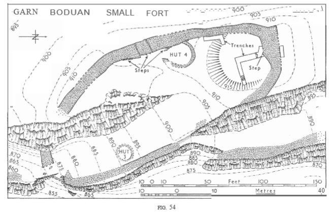
The Small Fort (Fig. 54).
The Small Fort crowning the summit of the hill is protected by a wall which differs in character from those of the large forts of Periods I and II, and excavation produced evidence that the structure is of late- or post-Roman date.Both faces of the rampart are well built, with a steep batter. The stones used are generally smaller than those of the hillfort ramparts, and the outer face is better finished than the inner. At the N. end of the fort, the thickness of the wall is greatly increased. The wall here has been spread and levelled, but it is impossible to say whether this represents slighting in antiquity or the work of early Ordnance surveyors. Access to the top of the rampart was provided by flights of steps formed of long stones projecting from the inner face (Plate 4). As originally built, the Small Fort had two entrances. That on the S. remained in use during the occupation of the fort . It controlled access along a shelf which led upwards into the enclosure by a uniform gradient. The crags on each side, above and below the shelf, are precipitous. The gateway itself is very ruinous and no details are visible, but it seems to have been a simple gap. The other entrance, on the W. (Plate 4), was originally a simple gap. It was then narrowed by building piers at the outer corners; there was some indication of corbelling over the angle between the S. pier and the passage wall. Finally, the gateway was blocked by a well-built wall filling the whole opening. The inner face of this blocking was provided with steps similar to those elsewhere in the rampart. Two hut foundations are visible in the enclosure. One of these, adjacent to the W. gateway, was excavated. It was of generally similar character to those in the large fort, but of slighter construction. It proved not to be earlier than the rampart, and is probably contemporary with it. Small fragments of very crude pottery were found on its floor. The Small Fort produced some rather inconclusive dating evidence. Among the ruins of the rampart at the N. end were several beads, and a fragment of mortarium rim. The latter is probably of the 2nd century A.D., and the beads could belong to any period from the 1st to the 7th century. The very coarse pottery found in the hut is not closely datable, but resembles that found in Dark-Age sites in the district. 2 It seems unlikely that it would have come into use until Roman pottery had ceased to be available. The name Boduan indicates the Residence of Buan, who is said to have been a grandson of Llywarch Hen, 3 and who should therefore have lived ca. 600 or 650. The Small Fort may therefore have been the actual residence of Buan, a with which the meagre dating evidence is not at variance. A brief description, without plan, appears in Arch. Camb., 1926 p. 437.
1 Arch. Journ., CXVII (1962), pp. 1-39. Z e.g. Pant-y-saer, Anglesey; Arch. Camb., 1934, p. 26. 3 Bonedd y Saint, p. 321, No. 17. The occasional appearance of an “n” in the name (e.g. Bodenean, Bodnean, B.B.C.S., VI, p. 261) probably represents a scribal error for ‘u’.
Condition: ruined but not much disturbed.
SH 31003930
195 14
32 SW
p211
Rhannwch - Share and Enjoy
http://www.geograph.org.uk/photo/276310
Garn Boduan May 2016
Above sumit looking towards Nefyn May 2016
more to be seen here- https://youtu.be/qP-dtpcf2fA