(1699) CARREG Y LLAM (Fig. 105), a small fort occupying the N. end of a rocky ridge rising to nearly 470 ft. above 0 .D. The sea cliff on the W. is steep and in places precipitous. On the N. the ground falls more gently to Porth Howel, while to the E. and S. beyond a narrow saddle the inland hills rise gradually.
The site was excavated on behalf of the Commission in 1954.1 It has since been destroyed by quarrying.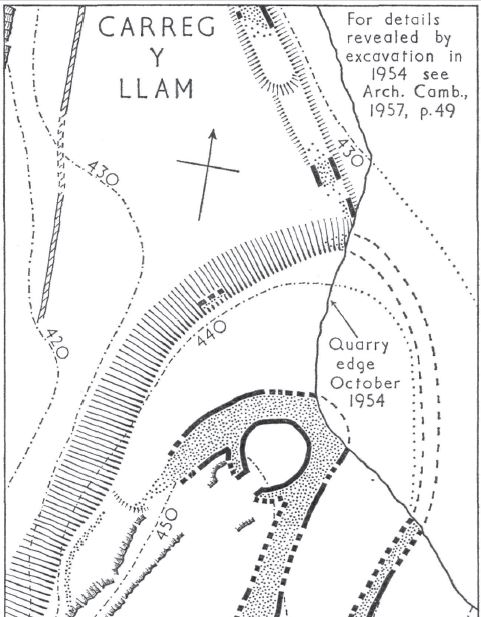
The defences consisted of two dry-built walls. The inner one enclosed an oval area 110ft. N.-S. by 40 ft.; it was 12 ft. wide, of rubble faced with laid masonry. About 30 ft. outside this stood a smaller rubble rampart, the outer face built of large blocks. Fifty feet to the S., the ridge is crossed by a third rampart, now reduced to a grass-grown scarp. North of the main enclosure a wall 7 ft. wide extended N.W. to enclose a triangular area with the sea cliff as its W. boundary.
The outer gateway, on the S.E., was approached by a trackway, generally about 10-12 ft. wide, slightly cut into the hill on the W., and on the E. terraced and edged with large boulders. The line cut the contours at an acute angle giving an easy ascent. The gateway was a simple gap with no structural features or post-holes. The terraced trackway ended at the outer gateway, from which the approach to the inner gate ran straight up the steep hillside. The inner gateway was much ruined, particularly on the N., and seldom stood more than one course high. The passage appears to have been 10 ft. wide, reduced at its outer end to 5 ft. by projecting piers. The whole plan of the S. side was recovered, showing that the pier was of one build with the wall; a small oval post-hole, cut into the rock to a depth of about one foot, was found just behind the pier; no other post-holes existed. The N. end of the inner enclosure proved to have been occupied by a hut, apparently the only dwelling on the site. This was nearly circular, 20-21 ft. in diameter, with an entrance 6 ft. wide on the S.W. Two-thirds of the wall was formed by the inner face of the rampart, here varying from 10 ft. to 14 ft. in thickness. The remainder of the hut wall was of one build with the rampart, though for much of the circuit rock outcrop was used. The hut was entered from the main enclosure by a roughly paved passage about 6 ft. long down two steps. Except where the rock was exposed the hut floor was roughly paved and on this was a hearth.
The finds during the excavation included pebbles, and boulders of various sizes brought from the beach, two small worked stone balls, and a few fragments of post-Roman pottery, probably of 8th- or 9th-century date.
Condition: destroyed (1960).
SH 33404365 1954-5 32 N.W. Unnoted
Rhannwch - Share and Enjoy
Golygfa tuag at bentref Pistyll, carreg y llam a’r Eifl o draeth Nefyn, Gorffennaff 2014